We were walking back from dinner and were looking to verify the location of the famous Tapestry when we came upon this opposite side view of the Cathedral.
Bayeux was founded by Gauls, eventually became a Roman center and then was successively conquered by the Bretons, the Saxons and the Vikings. In the courtyard of the church there is an exhibit of what was discovered during an excavation. That depression just visible at the bottom of the picture includes a viewing area for a wall section there that has been dated to the late 3rd century and is believed to be part of what was the city wall.
So that's pretty old.
The guidebook says one day should be plenty but I wasn't done yet so we headed back out to the beaches for another day, starting day two in the British sector at Arromanches. Arromanches was the site of Port Winston, one of two huge artificial harbors constructed along the invasion beaches to facilitate the landing of the engines of war that would push the Germans back out of France. There was one at Omaha Beach in the American sector and Port Winston in the British sector. The port at Omaha was destroyed in a huge storm within a couple of weeks of its construction. Port Winston survived that storm and served as the primary harbor for the landing of troops and materials until the liberation of Antwerp and its harbor in November of 1944. This was far beyond its planned life span. In fact, Port Winston hung on so well that vestiges of it can still be found along the beach and off shore at Arromanches.

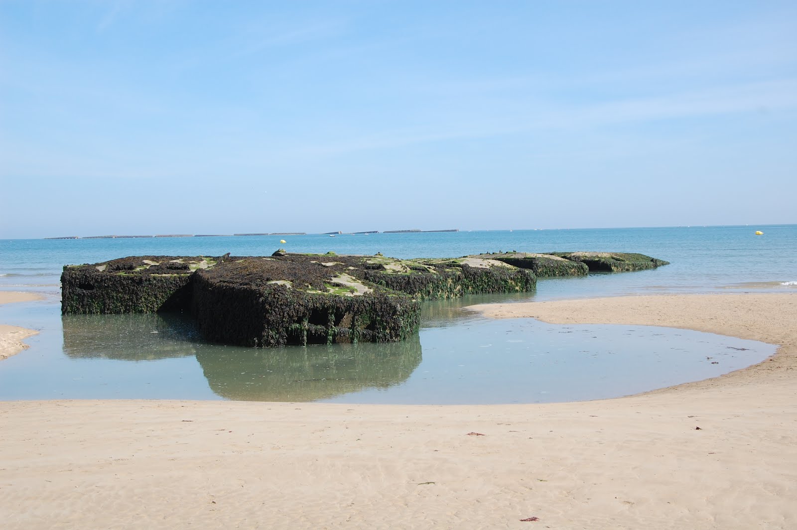
These are pontoons which in 1944 could be floated and which were extended out towards the make shift breakwater, making a road for the landing of heavy equipment.
This is a section of the famous Mulberry bridges, floating bridges. At Port Winston there were two of these bridges, useful for the landing of all but the very heaviest of vehicles (tanks).
We climbed first the streets and then eventually a stone and planking stairway to the top of the bluff overlooking the harbor. There are memorials up there, as expected, one of which is to two French shore batteries who helped a French fleet defeat an English fleet off shore here in 1811.
The tide is coming in, where I stood to take those earlier photos is now under water but you can see the, oh I don't know, harbor furniture? and the vestiges of the outer breakwater fairly well. Arromanches is yet another spot that is so pretty that it dulls your comprehension of what happened here.
It does not, and it should not, dull the commercial instincts of the local residents.
Here's today's bicycle content. In the parking lot at the beach at Arromanches three forms of transporation coexist: two bicycles loaded onto a rack on top of a car parked next to a half-track armored car.
By the way, it cost 1 euro per hour to park in that lot. I am guessing that the half-track was not a paying guest. This guess is fortified by the fact that that is a US half-track and the parking lot is in the British sector. It HAS to be a prop.
Our next stop after Arromanches was at Longues-sur-mer, still in the British sector. According to the guidebook after the war about 150,000 tons (300 million pounds) of steel was removed from the beach sectors and melted down to be reused. The guidebook says they didn't come anywhere near to getting it all. One place where they didn't get it all is the only surviving intact German battery, the four bunker complex at Longues-sur-mer.
There are four bunkers arranged in a semi-circle about 300 meters from the crest of the coastal ridge. These guns could fire with great accuracy at targets up to 12 miles away.
On one of the bunkers it is possible to get up on top. We got a photo which shows the relative distance from the coast of the place we are sleeping. You can just make out the three spires of the Bayeux cathedral along the horizon behind the FT.
To complete the picture, here is the forward observation post at the ridge line. No guns here, just guys with binoculars checking out the accuracy of your fire.
We had a picnic lunch out there at the ridge line, I have some spectacular photos from out there but those interested will have to arrange more time to take a look at that. Perhaps it will suffice at this time to say that it is an area of spectacular natural beauty, a high cliff overlooking a beautiful coastline. Some of it you can already discern in the photos I am publishing here. Some of it has to be seen to be believed.
Here's today's corn picture.
THEY GROW CORN IN FRANCE.
I don't know if the French have any interest in knee high by the 4th of July or possibly thigh high by Bastille Day but I do know that they are pretty lucky to grow any corn at all in that soil. Take a close look and it seems more like rocks with a little dirt, definitely way deficient when compared to Iowa black loam corn soil.
We headed on to our last stop of the day, the Ranger Monument at Pointe du Hoc.
Pointe du Hoc was the most heavily fortified position along the D-Day beaches. The Germans considered the position to be impregnable to ground assault as it sits at the top of steep ridges rising directly from the sea with no beach below.
The fortifications were for the purpose of withstanding what was expected to be heavy air bombardment.
The strongpoint had to be taken out because from this spot the Germans would have been able to direct fire at any and all shipping approaching both Omaha and Utah Beaches. There was no possibility of the American assaults on either of those beaches being successful without the neutralization of Pointe du Hoc.
The allies launched a heavy aerial bombardment which when it came was heavier than the German's imagined could have been possible. The land at the top of that point of land was turned into a moonscape of broken and shattered rock and soil. There just isn't any way to adequately describe it. Clearly photos fail. This is the best I could do and these photos are weak, weak depictions of what it looks like up there.
No attempt has been made to reclaim the land. It has been left as it was in June 1944. The moonscape has revegetated but the craters remain.
A force of 225 American Rangers were assigned the mission of taking the Pointe. They scaled the cliffs shortly after the completion of the nearly incomprehensibly heavy bombing runs. The Rangers made their ascent with rope ladders and grappling hooks and eventually reached the top where they were successful in defeating the no doubt disoriented and disheartened survivors of the original German force. The Ranger memorial is a rough hewn granite dagger thrust down into the heart of the German bunker at the point of the ridgeline.
I really tried to get some photos that show what it looks like up there. Here is what was a heavy reinforced concrete bunker which suffered a near direct hit. The concrete reinforcing rods are visible as is the depression next to the bunker which is where the bomb would have actually impacted.
And stepping back about 20 yards here is the same bunker with a view of what remains of the concrete structure immediately next to it, a structure which clearly suffered multiple direct hits.
It was a spectacularly beautiful Sunday afternoon on the coast of Normandy, not a cloud in the sky, temperatures in the low 20s.


No comments:
Post a Comment