Thursday, October 8, 2020

Fall again

The weather forecast is for 80 yet again tomorrow but today was a pretty normal October day.  The sun came out and the wind died down and the mercury rose to somewhere pretty near to average for this date.

I read in the newspaper that "peak" for fall colors here has been quite consistent over the past few years, generally occurring between October 14 and 19.  That means that the peak is near and if I don't want to miss out on it I need to start featuring photos of colorful trees.

That's Chelsea Street looking north from Hoyt Avenue.

On my last ride my mid-ride sitdown featured a search for shade.  With normal temperatures having returned, today I was looking for a spot in the sun.

That is a not very urban looking spot, I don't think, featuring a birch clump and a nice patch of a long stemmed decorative grass.  I have heard that birches do not do well in urban areas, they don't thrive in areas with air pollution.

Personally I think birches should suck it up and thrive.  If I have to breathe this air then they should get used to it too.

Regarding the news from Michigan is it possibly true that nearly every one of the individuals arrested could be described as a "West Michigan man"?

Tuesday, October 6, 2020

Intermediate pool

The Army Corps of Engineers is conducting a maintenance project on the stretch of river between the Upper and Lower Saint Anthony Lock and Dams, an area only several blocks in length known as the Intermediate Pool.  This is the area of the river near downtown Minneapolis crossed by the Stone Arch Bridge.  For reference, the Upper Pool is above the dams, the lower pool is below the dams stretching from the lower dam to the Lock and Dam Number 1, informally known as the Ford Lock and Dam.

The project involves opening the Lower Dam to lower or draw down the water level to allow for inspection of various parts of the generally submerged infrastructure.  This is done, I now understand, periodically but obviously not often as this is the first I have heard of such a thing.  Apparently this was last done in 2008.

The project will last about 10 days with today and tomorrow being the days when the water level will be at its lowest.  It was a nice day for a ride, sunny and warm with a bit too much southwest wind, but downtown Minneapolis is southwest from where I live making a ride over there today downhill into the wind with a gradual uphill with a strong tailwind return.  I set off.

Well, there were too many people there.  But it WAS outdoors and with a strong wind.  I don't ride with a face mask but I now do carry one in the pocket of my bicycle jersey so when I got there I put on my mask and coexisted for a bit with my fellow citizens.  As is often the case for me for such interactions I found the experience to be tolerable if only just barely so.

And I took some pictures.

This is from the bridge looking upstream with downtown Minneapolis is the background, the upper lock dominating screen center.

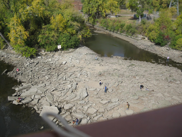
You can still make out the ordinary high water mark on the concrete, the river looks to be down about six or eight feet.  This is a significant amount when what the Corps is guaranteeing on this stretch of the Mississippi is a nine foot deep channel.  The river bed near the lock has come into view, evidence of what was at the time of settlement a series of rapids which extended from below the then natural falls all the way down the gorge to Saint Paul.

This one is near the west bank, what was originally Saint Anthony before the two cities merged.  That is a run out channel from one of the mills.  Visible is a modern navigation warning sign.  The warning is necessary as all of this area is now generally underwater if only just barely so, meaning that this is an area of extremely shallow water.

This is below the dam, vestiges of what I believe is the foundations for the 10th Avenue wagon bridge.  Of interest is again the rapids and potential navigation hazards.  The beginning of the lower lock structure is there on the left.  And again, that area where people are walking in the photo foreground is generally river bed.
I crossed the river and tried with limited success to find a viewing spot for the bridge itself and eventually settled for this.  Again, the ordinary high water mark is still visible on the bridge footings.

All in all it was a pretty good show.

But after that I has to get home and it was going to be mostly uphill.  I stopped for a mini-Clif bar at what is likely to be my only visit this year at a spot where we have been going 18-20 times a year for the past 15 years.  That is a NewLOOK at Ridder Arena, home of the seven time national champion Gopher Women's Hockey team.

Riding with a strong wind is hard.  I think today's effort was more strenuous than the now several days ago 20 percent extension of usual distance.  By the time I got home I was pooped.

But perhaps the news from the Petkoff time and temperature display had something to do with that.

That was about 3:45 and qualifies yet again as probably the last 80 degree temperature for several months.  I turn left there and I can be home in 0.63 miles (5 blocks).  I can make it from there even when I am pooped.

My yearly mileage total at the end of the ride is 1,006, which is good.  I passed 1,000 while struggling on the uphill on Como past the Fairgrounds which is a hill which in my prime I charged.  But accentuating the positive there are still 3 or 4 or 5 or who knows for sure more weeks to ride this year.

It was an exceptionally nice Tuesday in early October.

Sunday, October 4, 2020

Piling up frequent visitor points

I had not been there even a single time this year until just last week but favorable conditions moved me down into the really big city and over to this place.

Visible on the footbridge over the creek just above the Falls is what for that venue is quite typical social distancing.

Well, it is outdoors but it doesn't feel safe to me down at that end of the gorge.

I have one other place on my list that I still may try to make it to later this week when the weather is predicted to be gorgeous (possibly allowing another ride or two this year in shorts).  I considered that today but to get there I would have to ride through part of the main campus of the University and my thinking about that has evolved to the point that I think that I should limit as much as possible my exposure to students.  It just doesn't feel safe.

The sun was out today making it a really nice Sunday in October.  The temperature was about 50 at the start but I do have the gear.  It is interesting as the end of the season approaches and I start to have discussions with myself about what my floor temperature for starting a ride is.  Often and in fact, this year, I imagine to myself that 50 is about as cool as I will attempt.  Then a day like today comes around and it is clear that I have several more degrees below that point where comfort is very possible.

It is mostly still pretty green in Minneapolis.  Lots of the yellows have come and lots of those leaves are down but most of the bright oranges and reds are not here yet.  I think it is really pretty right now.  I leaned my bicycle against a sign providing hours and conditions of allowable parking and sat on a nearby retaining wall for a mid-ride sit down and got this picture.

I was riding roughly along the River Road.  The shared pavement which surprisingly manages with two painted lines, one solid and one dashed, to serve quite well as both a pedestrian and a bicycle path is over there on the other side of where the cars are passing.  Where I was was on Edmund Boulevard just about even with the south property line fence of the Dowling School.

In case anyone wants to know.

On the way home rather than ride up the Pelham hill, I rode around it.  Obviously you cannot really avoid the change in elevation, you can only flatten the curve.  I did that and it ended up taking more miles to do than what I had expected.

But I remembered this tree in Saint Paul from years past and wanted to check the colors in the other big city.  That's Dayton and Wheeler, a really striking maple in front of a stately old cottonwood, both standing out from the cerulean blue sky of one really excellent day for a bike ride.

The extra miles involved in flattening that hill stretched the ride out to the distance that I have been riding of late.  I am still feeling the effects of the Vadnais ride of only two days ago and intended that today would be easier.  It's okay though, it felt great.

Friday, October 2, 2020

LOOK at Lake Vadnais

I have had this nagging desire to try this for a month or so now.  My average ride has been of a sufficient distance and my comfort in being able to complete that distance have encouraged me to think about the old standard ride that I did so many times when I was just a little bit closer to prime.  The extra distance was sobering, an increase of 20 percent over my previous long ride, and the fact that part of that extra distance would have to be a long uphill made me hesitant.

But today I just decided to go for it.  It was definitely cool, a high temperature of only 50, but I have the gear, and the day was sunny and nearly without any breeze.  As I started my ride it just started to feel like a day when I could do it.

So I took my longest ride of the year and revisited Lake Vadnais.  New gear for today's ride included a full head covering (including my face which of course fit right in in today's world), full fingered gloves, a fleece vest and my heaviest bicycle jacket.  My fingers were not totally comfortable but in general the gear was a success and I rode in comfort.

There were lots of people fishing out there today and many more walkers than bikers but here it is, a LOOK at Lake Vadnais.

Really nice bike at about the 10.5 mile point in today's ride.  I knew I wasn't yet quite at the half way point but I did know that it was time for a short sit down and an energy bar.

I wanted to wait for the sun for a photo of the lake but it was taking too long and the colors aren't vivid yet so finally I settled.  Maybe I should have waited, those clouds were much more dramatic looking when the lighting changed.

The ride was not quite actually the old standard ride, today I rode it in the reverse direction.  That means that I got to the lake before the half way mark instead of after and the uphill was longer but not as steep as the up to Rice Street climb on the south end of Vadnais.

But I did get all the way to the Highway 96 end of Sucker Lake and went around the roundabout in that park as the turn back point, as is the case on the standard ride.

It was too far and I was feeling it in my neck as I ground out the final four miles but I made it home under Gzmoohoo power so I guess maybe it wasn't too far.

Here is a picture I took at Lake Como several days ago on a day when I did ride but for some reason did not post.

You can see the lake peaking through the trees frame right but what I like about this spot and why I took the photo, other than the bench I was sitting on, is there are two paths around this lake, one for pedestrians over there nearer to the lake, and this one, which is marked all the way around with painted bicycle symbols.

And that blue stripe along the away from the lake edge of the path.

I suspect that I am one of many mystified by that stripe.  I wonder whatever it could possibly mean.