The Army Corps of Engineers is conducting a maintenance project on the stretch of river between the Upper and Lower Saint Anthony Lock and Dams, an area only several blocks in length known as the Intermediate Pool. This is the area of the river near downtown Minneapolis crossed by the Stone Arch Bridge. For reference, the Upper Pool is above the dams, the lower pool is below the dams stretching from the lower dam to the Lock and Dam Number 1, informally known as the Ford Lock and Dam.
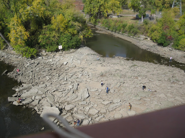
The project involves opening the Lower Dam to lower or draw down the water level to allow for inspection of various parts of the generally submerged infrastructure. This is done, I now understand, periodically but obviously not often as this is the first I have heard of such a thing. Apparently this was last done in 2008.
The project will last about 10 days with today and tomorrow being the days when the water level will be at its lowest. It was a nice day for a ride, sunny and warm with a bit too much southwest wind, but downtown Minneapolis is southwest from where I live making a ride over there today downhill into the wind with a gradual uphill with a strong tailwind return. I set off.
Well, there were too many people there. But it WAS outdoors and with a strong wind. I don't ride with a face mask but I now do carry one in the pocket of my bicycle jersey so when I got there I put on my mask and coexisted for a bit with my fellow citizens. As is often the case for me for such interactions I found the experience to be tolerable if only just barely so.
And I took some pictures.
This is from the bridge looking upstream with downtown Minneapolis is the background, the upper lock dominating screen center.
You can still make out the ordinary high water mark on the concrete, the river looks to be down about six or eight feet. This is a significant amount when what the Corps is guaranteeing on this stretch of the Mississippi is a nine foot deep channel. The river bed near the lock has come into view, evidence of what was at the time of settlement a series of rapids which extended from below the then natural falls all the way down the gorge to Saint Paul.
This one is near the west bank, what was originally Saint Anthony before the two cities merged. That is a run out channel from one of the mills. Visible is a modern navigation warning sign. The warning is necessary as all of this area is now generally underwater if only just barely so, meaning that this is an area of extremely shallow water.
I crossed the river and tried with limited success to find a viewing spot for the bridge itself and eventually settled for this. Again, the ordinary high water mark is still visible on the bridge footings.
All in all it was a pretty good show.
But after that I has to get home and it was going to be mostly uphill. I stopped for a mini-Clif bar at what is likely to be my only visit this year at a spot where we have been going 18-20 times a year for the past 15 years. That is a NewLOOK at Ridder Arena, home of the seven time national champion Gopher Women's Hockey team.
Riding with a strong wind is hard. I think today's effort was more strenuous than the now several days ago 20 percent extension of usual distance. By the time I got home I was pooped.
But perhaps the news from the Petkoff time and temperature display had something to do with that.
That was about 3:45 and qualifies yet again as probably the last 80 degree temperature for several months. I turn left there and I can be home in 0.63 miles (5 blocks). I can make it from there even when I am pooped.
My yearly mileage total at the end of the ride is 1,006, which is good. I passed 1,000 while struggling on the uphill on Como past the Fairgrounds which is a hill which in my prime I charged. But accentuating the positive there are still 3 or 4 or 5 or who knows for sure more weeks to ride this year.
It was an exceptionally nice Tuesday in early October.


2 comments:
Wow, interesting stuff. The Stone Arch Bridge is a significant place for me and mom and dad. I have walked across it countless times with them and friends, especially during the summer solstice. I love these pictures and the history.
Also, Ridder Arena!! I miss going there with you.
Great series of photos, interesting stuff. Nice ride report, too. Especially, "riding with a strong wind is hard." I'm going to try a short ride in strong winds today. 1,006 is more than good -- though I sense some optimism in the 3 or 4 or 5 weeks more to ride this year. I'll need all of that and then some to hit 1,000 miles this year, maybe even some Florida miles. We've had mild Novembers, but it's been a while.
Post a Comment